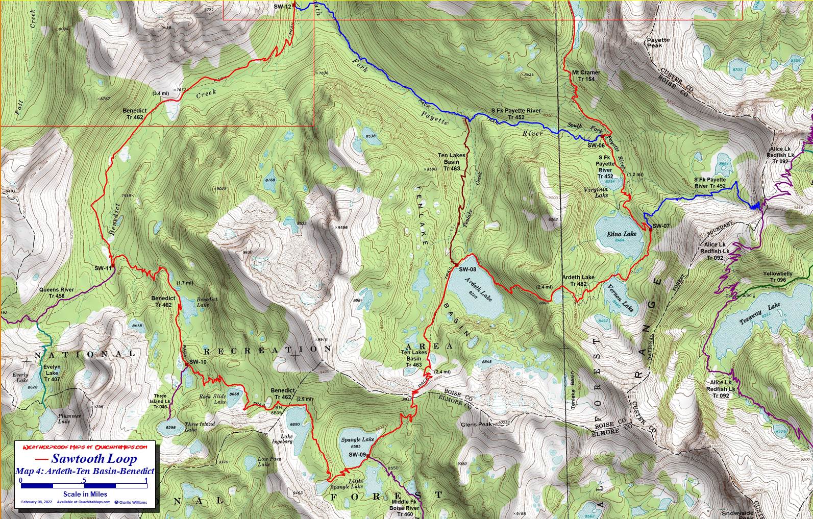
Map 4: Ardeth-Ten Basin-Benedict. The Mt Cramer Trail leaves Hidden Lake and switchbacks down to the SW-06 in the valley of the South Fork of the Payette River. SW-06 is 36.6 miles into the loop. The loop turns south-southeast (left) and follows the S Fk Payette River Trail (452. The trail is blue on the map but where it coincides with the loop, the red loop line makes it purple). Turning west (right) at the junction will lead to SW-12 in 3 miles, cutting 14 miles off from the loop.
Staying with the loop, it is 1.2 miles to SW-07 just above Edna Lake. This is the junction of the Ardeth Lake Trail (482, yellow with red). The South Fork Payette River Trail (452, blue) continues east climbing to another pass on the Custer-Boise county line and the Alice Lake-Redfish Lake Trail (092). The loop follows the Ardeth Lake trail for its 2.4 mile length, passing Vernon Lake, climbing a small pass, dropping down to Ardeth Lake and ending at SW-08.
SW-08 is 39.9 miles along the loop and the intersection of the Ten Basins Trail (463, red). Go south (left) to follow the loop. Turning north (right) will take you back to South Fork Payette River Trail (452), another short cut to SW-01.
The Ten Basins Trail (463) climbs 724 feet in the next 1.5 miles to cross another county line pass (this time it is Boise-Elmore). A quick 0.9 mile decent leads to SW-09, a triple junction at Spangle Lake, 42.4 miles in. Branching to the southeast (left) is the Middle Fork of the Boise River Trail (460, aqua). It is well over 15 miles to the trailhead at Power Plant Campground. Don't take it if you are on the loop.
The loop continues southwest along Spangle Lake but the trail has now become the Benedict Trail (462, green). Over the next 2.9 miles it passes Ingeborg Lake and Rock Slide Lake until it reaches another junction. This is SW-10, where the Three Lakes Island Trail (043, aqua) comes in from the south. Stay on the Benedict Trail and reach SW-11 in another 1.7 miles. SW-11 is 47 miles along the loop. It marks the Queens River Trail (458, teal) and a subsequent spur to Evelyn Lake coming in from the southwest. The next waypoint is SW-12 where the Benedict Trail meets the South Fork Payette River Trail (452, purple).